News
Summer School, Runoff Predictions in Ungauged Basins (PUB) - TU Vienna
Vienna Catchment Science Symposia at TU Vienna
Understanding water resource systems - Video
Research Highlights
Modelling the impact of drought on the ancient Maya

What was the role of rainfall in the demise of the ancient Maya civilisation? Mathematical models that link water and society can help us understand the past - and give insight into our own future.
The ancient Maya were a flourishing advanced society, but their population peaked around AD800 and then rapidly decreased. Large and well established cities were abandoned. There remains much debate about what caused this population collapse. Climate change that led to drought could be one reason. To explore this theory, Linda Kuil developed a mathematical model that couples rainfall, construction of water reservoirs, food availability and population. Mathematical interrelationships between food availability, birth rate, awareness to water scarcity and the capacity to build storage reservoirs were established. The model simulations, using estimates of rainfall data from the ancient Maya period, show how the reservoirs that the Maya built to cope with water scarcity, »More
Step changes – a step towards understanding big floods
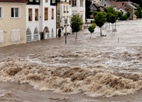
Understanding how floods occur is essential for their prediction. Considering catchment storage and critical thresholds will help overcome the inaccuracy of statistical forecast models.
Information on the magnitude and frequency of flood events is critical to ensure that infrastructure such as dams, bridges and flood protection measures are built to cope with high water levels. Engineers need to know how big a flood will be, and how often it will occur. Hydrologists traditionally provide this information using the flood frequency curve that describes how often water levels of a certain magnitude occur (e.g. every 5, 50 or 100 years). Smaller magnitude events occur more frequently than larger magnitude events. Hydrologists often fit a statistical model to available river flow data to predict how often a large flood event might occur. One problem with this »More
Searching out phosphorous emission hotspots
Phosphorous is essential for growing food, but it can also seriously damage water ecology. With the PhosFate model hotspots for water management solutions could be identified.
While essential for growing the food we eat, phosphorous can also be a pollutant, and can seriously damage the ecology of rivers, lakes, estuaries and even oceans. One of the major challenges in managing the use of phosphorous in agriculture is predicting and controlling how phosphorous applied to a field will reach a stream or river. This knowledge is essential to identify exactly where phosphorous applications are causing the greatest harm and should be controlled. Adam Kovacs and his co-authors addressed this challenge using a model to identify the location of emission hotspots in two agricultural catchments in Austria and Hungary. Because phosphorous usually moves around attached to particles of soil they applied an improved version of the PhosFate model »More
Advances in detecting faecal pollution

Genetic markers seemed to improve the search for sources of drinking water contamination causing diarrhoea. Research showed that genetic Bacteroidetes assays are not reliable enough.
Some 1.8 million people worldwide die every year from diarrhoeal diseases that result from drinking water contaminated with human faecal material. Identifying where and how water is contaminated is essential to help reduce risk. Traditionally, bacterial indicators such as Escherichia coli (E. coli) or intestinal enterococci have been used to indicate contamination with faecal material. These bacteria are commonly found in the intestines of warm blooded organisms and so their presence suggests faecal contamination. However, these indicators have also been found away from the intestines – for example, “naturalised” E. coli have been found in soil and sediments. »More
Identifying vertical vegetation structure with remote sensing
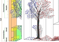
Remote sensing is a fast and accurate way to collect real-time information about the earth’s surface. Many creative applications are emerging that can help scientists understand water processes.
Airborne laser scanning is an efficient and cost-effective method to gain accurate data for large areas. Laser pulses are able to penetrate through the gaps in vegetation foliage. A dense laser data set shows a three dimensional image of the vegetation such as trees, shrubs and grassland, as well as showing the land surface under the vegetation. This information on the texture of the surface translates into “surface roughness”, i.e. how much the surface deviates from being smooth. The roughness of a floodplain has a strong influence on how water will move over the land surface during a flood event. It is therefore an important parameter for hydrologists interested in understanding water movement during a flood. »More

